D2R2 offers 8 routes for 2026 from a 12-mile Family Ride to the legendary 180K.
I had always believed a truly perfect moment on a bike would never come to pass, but this was perfect. This was magical.
Mike Magnussen, Bicycling Magazine, 2014
Navigation
PLEASE visit our D2R2 2026 Route Collection at RidewGPS to download GPX and FIT files this spring. Within the Collection, you will also find optional loops and bailout instructions.
PLEASE USE CUE SHEETS (linked below in Spring 2026) to navigate routes. Maps and GPS files are for basic reference but may have minor inconsistencies. In true Randonnée style - please use your cue sheet.
If you intend to only use a GPS to navigate the route, please at least take the time to read through the cue sheet pre-ride as it also contains important cautionary information as well as useful route divergence information.
180K (the OG that started it all!)
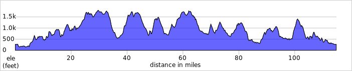
The original, the legend, the ride that started it all. The 180K is harder than anything most riders have ever experienced. Famous 100-mile trail races have faster times than our 180K. At the same time, people have described it as a journey so wonderful that they wished it indeed would never end. A grand tour of Franklin County's secret back roads. Bring the low gear you need to climb a 20 percent grade with 100 miles in your legs and plan for a full day. The new start and finish at the fairgrounds in Greenfield add 5 kilometers to the route but the name remains the same.
Start Time: 6:00 AM
Map: D2R2 180k
180K Route (FIT and GPX files) and Cue sheet
140K (formerly the 160K with some new twists & turns!)
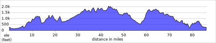
New for 2026 a route that follows the old 160k for the first 40 kilometers, then alters course to ride along the beautiful upper stretch of the Green River. The route travels North and West from there over little-used roads and charts a course to the new lunch site at Franklin Land Trust’s Crowningsheild Conservation Area in Heath. After lunch there are a few lumps and then a long paved downhill to Charlemont where it picks up the remainder of the original 160k. This route is shorter than the 160k, but it packs a punch with 86 miles and almost 9000 ft of elevation. Don’t plan anything else for the day!
Start Time : 7:00 AM
Map: D2R2 140k
140K Route (FIT and GPX files) and Cue sheet
110K (formerly the 105K)
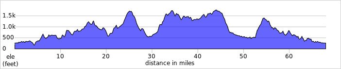
With a new lunch site at Crowningshield Conservation Area, the 105k runs 110k this year. Always billed as a more challenging alternative to the 100k, this year we took it up a notch. Covering 68 miles with almost 8000 ft of elevation, this is a challenging ride that is either going up or down. The first 30 miles are the same as the 105k, but the route to lunch is all new. If you find yourself in over your head, there is a shortcut at mile 30 that could spare you some steep climbs and 4 ½ miles on the way to lunch. Don’t forget, Patten Hill comes at mile 53!
Start Time: 8am
Map: D2R2 110k
110K Route (GPX and FIT files) and Cue Sheet
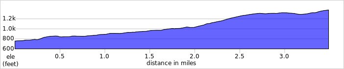
100K (The Original)
The Original 100K
The new start at the fairgrounds does little to change the 100k. The original 100K came about the very first year when RUSA administrator Don Podolski surveyed the 180K and politely suggested that a "junior" course would be a good idea. Indeed, half the riders took the short course that first year, and the 100K has been a staple ever since. The ride takes about as long as 100 miles on the road, and thus only here does it somehow get thought of as "the short course!"
Start Time: Original 100K - 9:00 AM
Map: D2R2 100k
100K Route (GPX and FIT files) and Cue Sheet

90K
Largely the same as the 92k from the past this is a route for those looking for more distance and challenge than the Green River Ride, but not quite as much as the classic 100k. Featuring lunch at Edge Hill Conservation Area, Franklin Land Trust’s newest conservation property, the route has everything you love about D2R2 – plenty of challenging climbs on quiet country roads with a scenic view around every corner. All in a slightly more manageable package!
Start Time: 9:30 AM
Map: D2R2 90k
90K Route (GPX and FIT files) and Cue Sheet
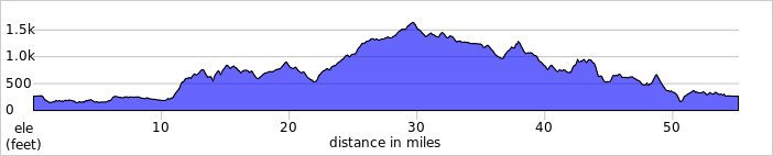
80K - Point to Point Ride (NEW!)
We are launching a completely new concept this year. Riders and their bikes will be transported to the Town of Florida at the height of land on the Mohawk Trail. They will ride back to the start. The route will include remote terrain in Berkshire County previously only included on our longest mystery rides from past years. While there will be hills and a few rideable jeep track sections for sure, the fact that you will end up almost 2000 feet lower than you start means there will be less overall climbing. Lunch will be at Edge Hill.
Start Time: TBD
Map: D2R2 P2P Florida to Greenfield
80K Route (GPX and FIT files) and Cue Sheet
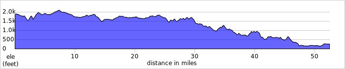
Green River Tour (customizable from 36 to 52 miles)
The Green River Tour was sparsely attended for years, but finally the word is out that there is a way to enjoy the mystique of D2R2 without having to climb mountains. The first quarter is on the pavement, the middle half follows Green River Road with an optional climb before lunch, and the last quarter is paved. The hills are minimal, and totally doable pulling a trailer. And ... it's Green River Road, which speaks for itself.
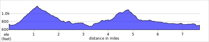
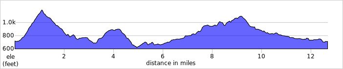
New this year are two optional loops from the covered bridge lunch site to add 8 or 13 miles and some challenging hills.
Start Time: 10:00 AM to 11:00 AM
Classic: GR Route (GPX and FIT files) and Cue Sheet
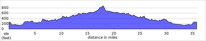
Add on loop 1 (7.7 miles)
7.7 mile loop: Loop1 (GPX and FIT files) and Cue Sheet
Add on loop 2 (12.7 miles)
12.7 mile loop: Loop2 (GPX and FIT files) and Cue Sheet
12 or 16 mile Family Ride
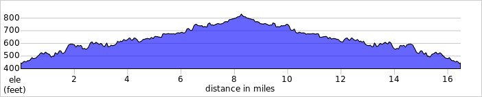
The Family Ride is designed for those riders with small children or riders who want to enjoy the D2R2 experience with a more modest physical challenge. The majority of this ride is on a relatively flat dirt road that runs adjacent to the Green River. The hills are minimal, and totally doable pulling a trailer. And ... it's Green River Road, which speaks for itself.
PLEASE NOTE: The Family Ride will START near 10-mile bridge. Registration will be near 10-mile bridge as well. Lunch will be served at the covered bridge in Guilford with the rest of the routes.
Start Times: 10:00 AM - 11:00 AM
12 mile Map: D2R2 Family Ride
12 mile Family Ride Route (GPX and FIT files) and Cue Sheet
12 miles - to lunch at Guilford Covered Bridge and back
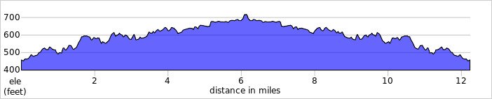
16 miles - to end of Green River Road and back
16 mile Family Ride Route (GPX and FIT files) and Cue Sheet